Skip to content
Themes
Digital Twin
Urban Planning
Climate Resiliency
Environmental Impact
Water Safety
GIS and Data Analytics
Knowledge Base
Features
Blogs
Webinars & Events
Tygron Academy
Universities
About us
About Tygron
Contact
Job Opportunities
Support
NL
Menu
Themes
Digital Twin
Urban Planning
Climate Resiliency
Environmental Impact
Water Safety
GIS and Data Analytics
Knowledge Base
Features
Blogs
Webinars & Events
Tygron Academy
Universities
About us
About Tygron
Contact
Job Opportunities
Support
NL
Contact us
December 5, 2023
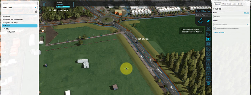
Adding a GeoTIFF to a measure
Roadmap
Adding a GeoTIFF to a measure
1
1 year ago
tygron
Released on Preview 2024
0
Attachment
Feature
Adding a GeoTIFF to a measure
Very useful for e.g. including a new height map in a measure – for calculating the impact of an urban plan on water nuisance.
Documentation:
https://previewsupport.tygron.com/wiki/How_to_add_a_GeoTIFF_to_a_measure
Search
Search
Related posts
The Tygron Platform: Independent from American Cloud Providers
Read More »
Get started with AI yourself: Open source and accessibility on the Tygron Platform
Read More »
Renewed license structure Tygron Platform 2025
Read More »
How do we use AI to better retain precipitation where it falls?
Read More »
ISO 27001 Certification for the Tygron Platform
Read More »
Privacy Preferences
When you visit our website, it may store information through your browser from specific services, usually in form of cookies. Here you can change your privacy preferences. Please note that blocking some types of cookies may impact your experience on our website and the services we offer.
I Consent
Required